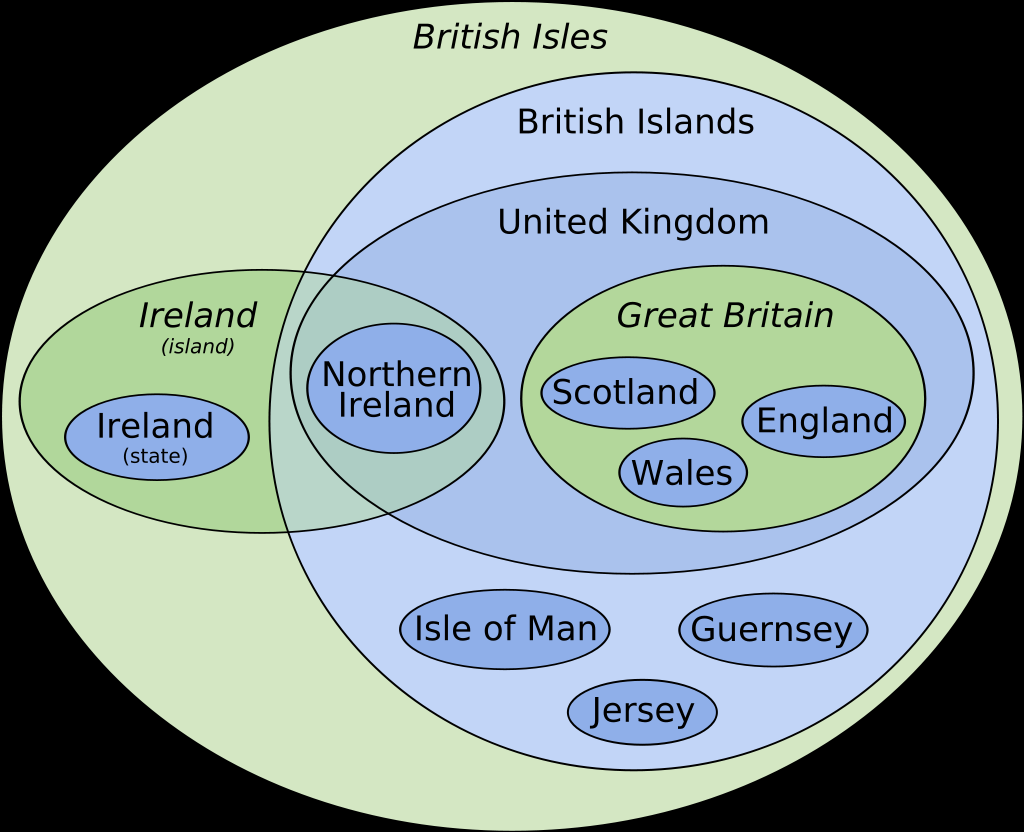
The term British Isles is, of course, disputed by the Irish.
Data Is Beautiful
A place to share and discuss data visualizations. #dataviz
(under new moderation as of 2024-01, please let me know if there are any changes you want to see!)
They had a signpost in the Atlantic saying “Irish Isles” for weeks before we noticed.
How about we collective reestablish the name "Albion", then?

I think this chart is out of date
Interesting though as it shows what "hard Brexit" was. Not in the customs union, economic area or council; just yeeted all the way out.
The best part is the voting slip never defined any of it and, if taken literally, the UK would still be in the EEA.
We’re currently alone in two new zones called “Fucked around” and “Found out”.
eg Croatia is now in the EU and Eurozone (maybe Schengen area too).
This chart: "England, Scotland and Wales are in Great Britain"
Wight, the Scillies, Anglesey, Sheppy, Anglesey, the Shetlands, the Orkneys, the Hebrides, and thousands more: "Are we a joke to you?"
I think Sheppey is a joke to everyone including the people that have to live there.
I’m trying to remember though, aren’t the Jersey, Guernsey, and Man somehow closer to Scotland or Wales status than say Sheppey or the Orkneys?
Yeah, the channel islands and the Isle of Man have more autonomy. Officially they are "self-governing British Crown Dependencies".
Jersey and Guernsey have different VAT rates for instance. For years, play.com was based in Jersey solely so they wouldn't have to pay VAT on most of the cheaper stuff they sold to the mainland.
Aren't those all part of one of the other three? The orkneys and Hebrides are part of Scotland.
That's my point: they're all part of England/Scotland/Wales, but they aren't part of Great Britain.
None of those are in Great Britain, because they are islands and therefore not part of the island of Great Britain.
But they are all part of England, Scotland or Wales which, according to the diagram, are within Great Britain...
FYI "British Islands" isn't a specific name whereas all the others are
I’m not sure I follow. It looks as specific in the diagram as all the other names?
It's not an actual term that is used though. "Great Britain" and "Ireland" are the names of the islands, "the United Kingdom" and "(the Republic of) Ireland" are the names of the sovereign states, "the British Isles" is (one) name for all the bits of land. "British Islands" is not an official term or one that anyone uses.
Huh, is that the old Jersey?
Yup. Though original is probably the better description.
The new jersey is extra crispy
They prefer the term "Jersey Classic"
Ye Olde Jersey
A quiet little tax haven full of polite stuffy old people. I'm thinking of visiting the new one, I assume it's much the same?
This is a good way to distinguish the terms. I wonder if there is a good colour scheme to also indicate the nation states as district from the landmasses
I just call em all cunts, except for the irish those cunts are cool.
As a Englishman, I can't have you talking down on the Scots. They're the only ones left which are still decent
So you're saying they're decent cunts?
Now if someone can tell me what exactly "Britain" is? People say it all the time, like this is the largest statue of a vulva in Britain. Just shorthand for Great Britain, or is it something else?
Just that - shorthand for Great Britain. Easier to use when you don't think it's so great, like if you live in the Republic of Ireland!
Republic of Ireland
Which on the diagram is coterminous with “Ireland (state)”?
Exactly - that's it's proper name and how it's distinguished from Northern Ireland since they share the land mass of Ireland
You did a great job on this though, OP. It's difficult to explain to non-nationals with no idea of the history, so this is very helpful
Most people not from the UK will use "Britain" as an alternative word for "England".
It's like saying America to mean the United States. Technically America includes Canada and excludes Hawaii. But when people say America they actually mean US + Alaska and Hawaii but not Canada.
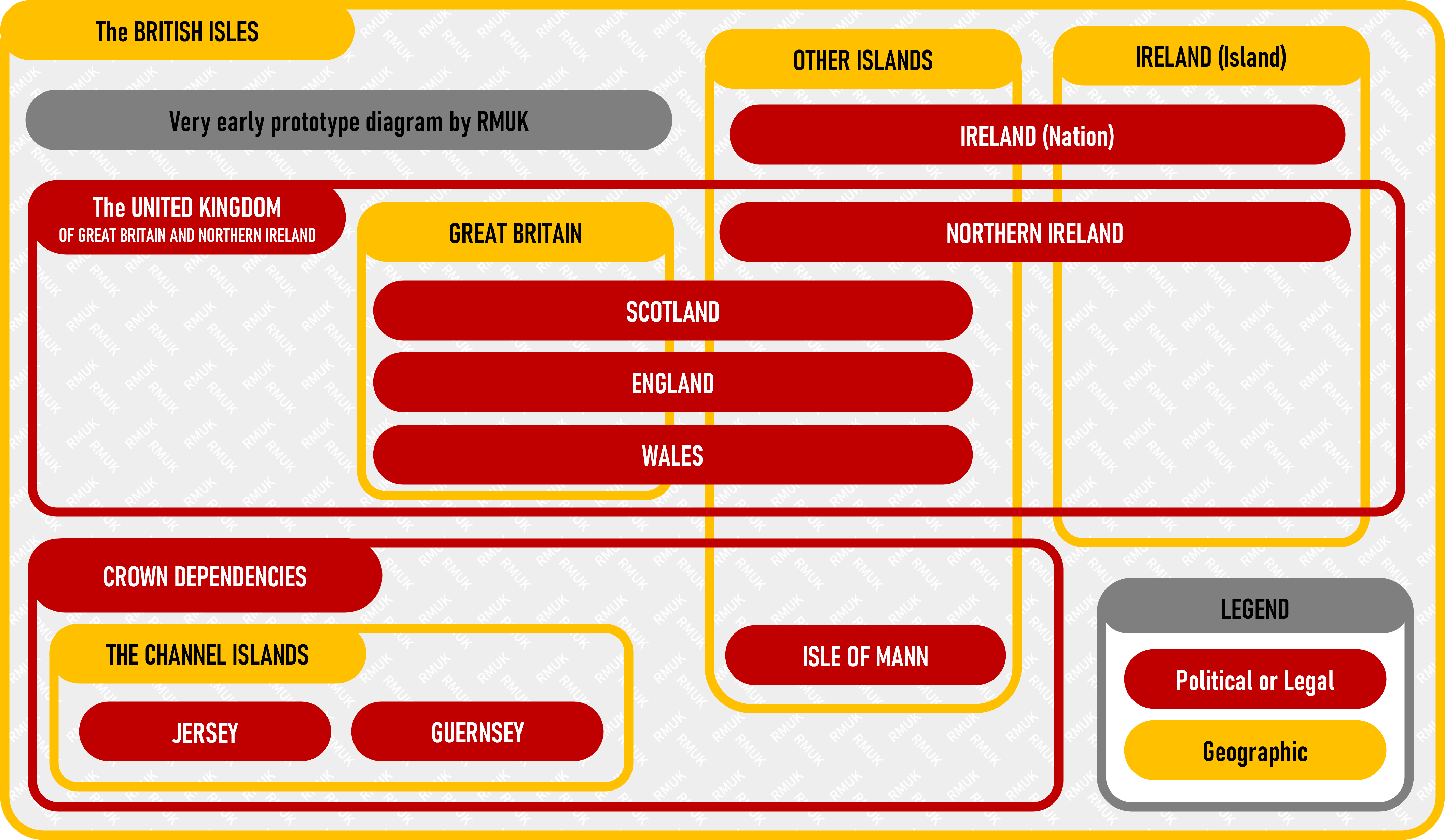
So I'm late to the party here, but this is a very early version of a diagram I'm putting together that corrects a couple of issues with the diagram OP posted.

As I said: very early and also very incomplete, but what's there is accurate.
I’m into it! I can’t wait to see where this goes.
they call the state ROI (republic of ireland) to distinguish between the island
